Follow the Glow: How Well-Lit Is Your Borough?
Explore average lighting conditions across London. Drag the map for details or click to zoom.
We've gathered and combined street lighting data from all London borough councils to create this interactive map of London's night-time visibility. Every road segment is colour-coded to reflect its lighting level — from well-lit to completely unlit — helping pedestrians, urban planners, and safety advocates better understand where light guides the way... and where darkness prevails.
Street Lighting Across London’s Boroughs
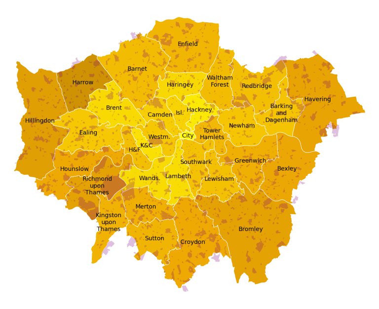
We calculate a simple metric to compare street lighting between boroughs — the share of paths that are fully lit. "Fully lit paths" are defined as having a lamp post every 30 metres, which aligns with common urban lighting practices. While other lighting sources like store fronts and building illumination contribute to street luminosity, especially in busy commercial areas, they are not accounted for in this map.
Not surprisingly, busy and densely populated central London boroughs have a higher share of fully lit streets than more residential, outer boroughs.
Path lighting is typically limited or intentionally reduced in parks and other green spaces. So when comparing boroughs, it's important to consider what share of each borough is covered in green areas (including play fields, golf courses, and cemeteries), as shown in the accompanying table.
For example, only around 40% of streets in Richmond upon Thames are classified as fully lit, but this borough is home to the massive Richmond Park and many other open spaces that naturally have unlit paths.
Notice something that doesn't match your experience?
If you spot a street that feels darker (or brighter) than shown on our map, or have any questions about the data, we'd love to hear from you. Your local insights help us improve accuracy and identify areas needing attention.
We assemble lighting data from a variety of sources, including London borough councils, TfL, Mappilary, satellite imagery, and other sources.
This data powers Safest Way, our safe walking navigator now available in London on the App Store.
Download the app, walk smarter, and share your feedback. We’re building this together.
We map lighting, greenery, street infrastructure, crime patterns, and visual safety features using computer vision — and we’re ready to share these insights to help you create safer, more welcoming, and inclusive urban spaces.
Want to learn more?
The map to keep you safe.
Privacy policy
Terms & Conditions
Say hello@safestway.co.uk
And connect with us on social media!
Subscribe to our newsletter!
Copyright (C) 2026 Safest Way. All rights reserved.